Showing posts with label ARC GIS. Show all posts

Thursday, October 20, 2016

How to Use Arc Map Selection to add to Domains in #InfoSewer and #InfoSWMM

How to Use Arc Map Selection to add to Domains in #InfoSewer and #InfoSWMM:
  1. Use the Arc Map Selection Tools
  2. Select a layer of Nodes or Links in Arc Map
  3. Add your elements to the Arc Map Selection and finally
  4. Add the selected elements from Arc Map to the InfoSewer Domain (Bullet 4)

How to Use Arc Map Selection to add to Domains in #InfoSewer and #InfoSWMM


Sunday, October 2, 2016

Arc GIS Tools for 2D Polygon Processing

Arc GIS Tools for 2D Polygon Processing
Clip – restrict data to area of extents
Buffer – offset polygon data
Dissolve – merge polygons
Multipart to Singlepart – make features individual (need to run after using dissolve)
Repair geometry – fix bad geometry
Erase – remove features inside areas
Integrate – align polygons


Monday, December 21, 2015

Job Posting - Sediment and Water Quality Transport in Urban Watersheds Research Participation Program Office of Research and Development National Risk Management Research Laboratory U.S. Environmental Protection Agency (EPA)

Sediment and Water Quality Transport in Urban Watersheds
Research Participation Program
Office of Research and Development
National Risk Management Research Laboratory
U.S. Environmental Protection Agency (EPA)

EPA-ORD/NRMRL-WSWRD-2015-04

Project Description:


Extra Note: Water resources job opening with in Cincinnati, Ohio for someone with a masters or PhD:
A postgraduate research project training opportunity is currently available at the U.S. Environmental Protection Agency’s (EPA), Office of Research and Development (ORD)/National Risk Management Research Laboratory (NRMRL). The appointment will be served with the Water Supply and Water Resources Division (WSWRD) in Cincinnati, Ohio. 
The WSWRD conducts research on microbial contaminants, water treatment technology, urban water management, and water quality controls for the benefit of the nation. 
The research opportunity will include activities such as:
  • Formulation of numerical techniques for simulation of nutrient and sediment water quality transport.
  • Development of initial solution prototype.
  • Testing of prototype with analytical, synthetic, and field study data.
  • Development of production code for SWMM based on prototype experience
  • Preparation of research products documenting methodology and results. 
The research participant will gain:
  • Experience with numerical solution of advection-diffusion-reaction equations
  • Knowledge of overland flow hydrology and numerical simulation of open channel flow hydraulics
  • Experience with object oriented software design
  • Experience developing software in C/C++.

Qualifications:

Applicants must have received a master’s or doctoral degree in civil/environmental engineering, hydrology, environmental science, or other related discipline within five years of the desired starting date, or completion of all requirements for the degree should be expected prior to the starting date.
The program is open to all qualified individuals without regard to race, sex, religion, color, age, physical or mental disability, national origin, or status as a Vietnam era or disabled veteran. U.S. citizenship or lawful permanent resident status is preferred (but a candidate also may hold an appropriate visa status; an H1B visa is not appropriate). Guidelines for non-U.S. citizens may be found at http://orise.orau.gov/epa/applicants/immigration.htm. 
The appointment is full time for one year and may be renewed upon recommendation of EPA and contingent on the availability of funds. The participant will receive a monthly stipend. Funding may be made available to reimburse the participant's travel expenses to present the results of his/her research at scientific conferences. No funding will be made available to cover travel costs for pre-appointment visits, relocation costs, tuition and fees, or a participant's health insurance. The participant must show proof of health and medical insurance. The participant does not become an EPA employee.

Technical Questions:

The mentor for this project is Michael Tryby (tryby.michael@epa.gov). 

How to Apply:

An application can be found at http://orise.orau.gov/epa/applicants/application.htmPlease reference Project # EPA-ORD/NRMRL-WSWRD-2015-04 when calling or writing for information.

Tuesday, December 1, 2015

@INNOVYZE Smart network modeling for effective planning of sustainable urban areas

Smart network modeling for effective planning of sustainable urban areas.
Journal of the American Water Works Association, 107(12), December 2015.

Sunday, November 22, 2015

Friday, November 20, 2015

BMP, LID, SUDS, WSUD E INFRAESTRUTURA VERDE – PRÁTICAS QUE REVOLUCIONAM A DRENAGEM URBANA

This page has very good graphics on LID and SuDS
http://www.aquafluxus.com.br/bmp-lid-suds-wsud-e-infraestrutura-verde-praticas-que-revolucionam-a-drenagem-urbana/
 
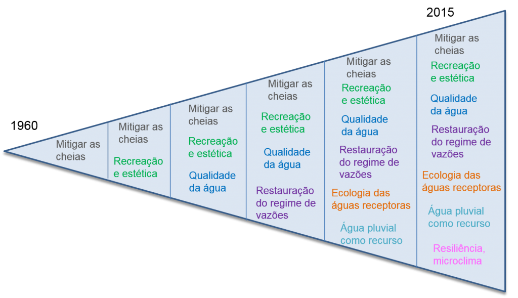
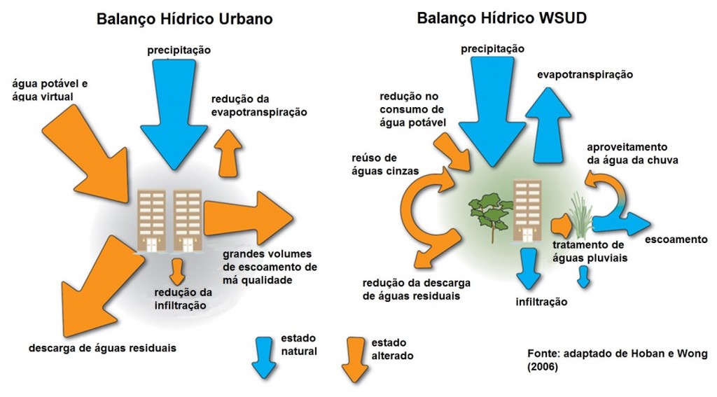
A urbanização provoca modificações no ciclo hidrológico, alterando suas parcelas e o balanço hídrico da bacia hidrográfica. A urbanização desordenada associada à falta de manejo e ao uso inadequado do solo provoca a redução da capacidade de armazenamento natural dos deflúvios, modificando os padrões de drenagem. A solução tradicionalmente adotada para a drenagem urbana visa o aumento da velocidade dos escoamentos com obras de canalização dos rios, o que acaba transferindo o problema para jusante e implica em continuadas intervenções localizadas após eventos de inundação. No entanto, uma abordagem mais atual, a chamada Drenagem Urbana Sustentável, busca soluções que proporcionam aretenção artificial das águas pluviais, a fim de compensar as perdas na retenção natural. A figura abaixo mostra a evolução da gestão da drenagem urbana ao longo dos anos, que no princípio tinha como objetivo apenas mitigar a ocorrência de cheias e que hoje objetiva também a melhoria da qualidade das águas drenadas, a restauração do regime de vazões, o aproveitamento das águas da chuva, entre outros.

triânguloevolução drenagem
A drenagem sustentável tem como focos principais:
  • respeitar o funcionamento natural da bacia hidrográfica;
  • minimizar os impactos da urbanização;
  • melhor controle sobre os riscos de inundações;
  • menor custo com readequações do sistema de drenagem (custos com “reinvestimentos”).
Os projetos de sistemas de drenagem sustentável buscam soluções para a drenagem evitando que os problemas sejam transferidos para áreas vizinhas, bem como a diminuição do impacto do empreendimento no sistema hídrico e garantia de sua sustentabilidade. Nas últimas décadas foram propostas diferentes abordagens nesta mesma temática, todas com um objetivo comum de resgatar as características naturais do ciclo hidrológico e proporcionando, ao mesmo tempo, ambientes mais agradáveis, como já apresentamos aqui no Blog em outros posts.
A seguir são apresentadas, resumidamente, as principais abordagens e as características de cada uma.
Melhores práticas de gestão – BMP (Best Management Practices)
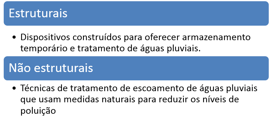
É um conjunto planejado de ações implementadas na bacia, com o objetivo de atenuar os impactos da urbanização, buscando reduzir a quantidade de água lançada no corpo receptor através da infiltração, e também melhorias na qualidade dessas águas. Exemplos típicos de BMPs incluem dispositivos de detenção ou retenção, instalações de infiltração e wetlands. Um exemplo de projeto com o uso destas técnicas foi apresentado no post EXEMPLO DE BMP PARA CONTROLE DE INUNDAÇÕES – LOS ANGELES, CA. As BMPs atuam tanto com medidas estruturais quanto com medidas não estruturais.
BMP
Desenvolvimento de Baixo Impacto – LID (Low Impact Development)
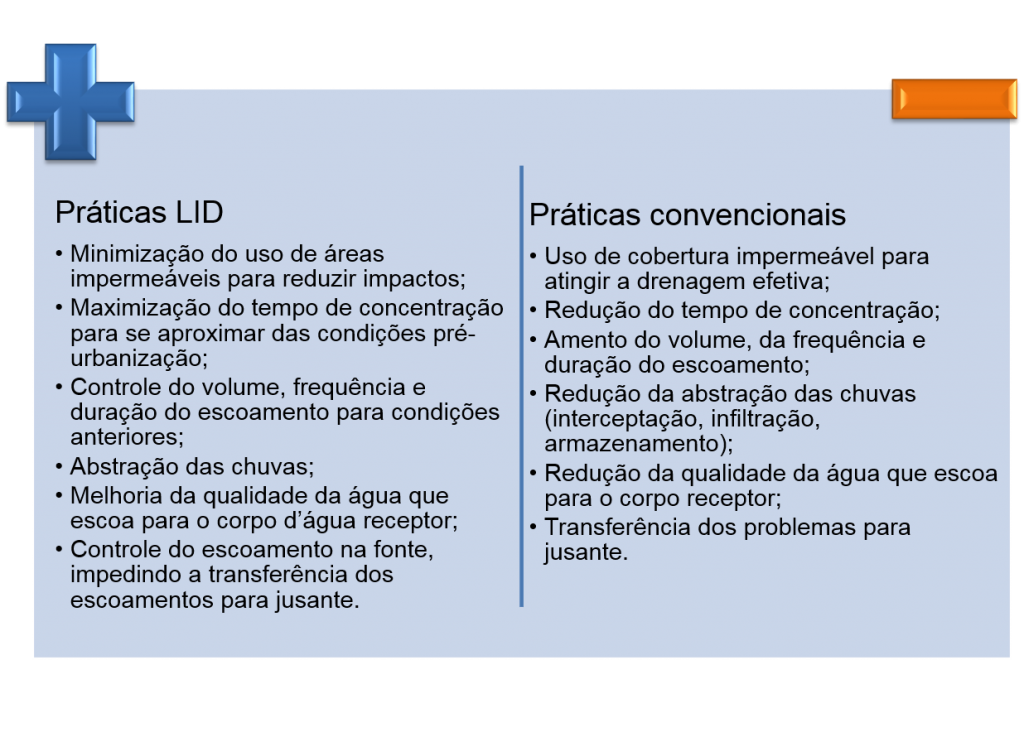
Considera o problema de forma integrada, tentando resgatar as características naturais do ciclo hidrológico, enquanto agrega valor à própria cidade. Projetos com uso de LIDs são elaborados de forma a se criar uma “paisagem multifuncional” capaz de incorporar características de projeto que buscam simular as funções de infiltração e armazenamento da bacia pré-urbanizada. Essa técnica foi bem explicada no post CRIANDO CIDADES SUSTENTÁVEIS. Abaixo são apresentadas as principais diferenças entre as práticas LID e as práticas convencionais.
LID
Técnicas compensatórias
Buscam favorecer a retenção e infiltração das águas precipitadas, visando o rearranjo temporal das vazões e a diminuição do volume escoado, reduzindo a probabilidade de inundações e aumentando a qualidade das águas pluviais. Tem como princípio inicial: manter as mesmas vazões das condições de pré-urbanização, buscando compensar os impactos da urbanização por meio da redução do volume de escoamento superficial, das vazões de pico e consequente redução da vulnerabilidade das áreas urbanas a inundações. O post O IMPACTO DAS TÉCNICAS COMPENSATÓRIAS apresentou um projeto acadêmico que testou o uso dessas técnicas.
Para saber mais sobre as técnicas compensatórias leia o post 5 MANEIRAS SIMPLES DE MELHORAR O CONTROLE DAS ENCHENTES URBANAS.
Sustainable urban drainage systems – SUDS
Desenvolvidos para melhorar o desenho urbano e a gestão de riscos ambientais, assim como promover a melhoria do ambiente construído, buscando reduzir os escoamentos superficiais através de estruturas de controle da água pluvial em pequenas unidades. Inclui medidas não estruturais como layouts alternativos de estradas e prédios para minimizar a impermeabilização dos solo e maximizar seu uso.
Water sensitive urban design (WSUD)
Como Osvaldo escreveu no post MANEJO DE ÁGUAS PLUVIAIS: QUEM ESTÁ INOVANDO NA ÁREA? , esse conceito “implica em inverter a lógica de adaptação dos sistemas hídricos às necessidades da cidade para uma abordagem de adaptação da cidade ao ciclo hidrológico, mitigando ao máximo os impactos da urbanização e aproveitando todo o potencial da água na paisagem e na vida urbana.”
Os princípios básicos são:
  • gestão integrada de água potável, águas residuais e águas pluviais;
  • integração da gestão das águas urbanas na escala individual do lote à escala regional;
  • integração da gestão sustentável das águas urbanas, arquitetura e paisagismo; e
  • integração das medidas estruturais e não-estruturais no manejo sustentável das águas urbanas.
wsud
Infraestrutura verde – GI (Green Infrastructure)
A infraestrutura verde coloca a conservação da biodiversidade num contexto político mais vasto, no qual os objetivos primários da conservação da natureza são alcançados em estreita harmonia com outros objetivos de uso do solo relacionados, por exemplo, com a agricultura, a silvicultura, o lazer e recreio e a adaptação às alterações climáticas. Intervenções urbanas que utilizam práticas da Infraestrutura Verde podem proporcionar maior infiltração da água e sua filtragem, bem como evapotranspiração e evaporação, reduzindo os efeitos de ilhas de calor e promovendo um melhor quadro climático na cidade. Além de atuar na gestão das águas pluviais também contribui na redução das enchentes e na melhoria da qualidade do ar. É o conceito mais amplo, dentre todos os apresentados.
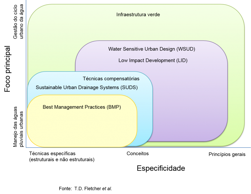
O quadro abaixo, apresentado no artigo SUDS, LID, BMPs, WSUD and more – The evolution and application of terminology surrounding urban drainage, publicado no Urban Water Journal, apresenta as diferentes concepções de acordo com suas especificidades e foco principal.
Tudo junto
Para saber mais sobre drenagem sustentável leia os posts:
DRENAGEM URBANA: CLÁSSICA X SUSTENTÁVEL
MAS QUAL É A VANTAGEM DA DRENAGEM SUSTENTÁVEL?)

Saturday, November 14, 2015

New - Five Infiltration Options Now in InfoSWMM v14 and H2OMap SWMM v14 for Watershed Modeling

Infiltration from the pervious area is a marvelous and from a runoff volume and runoff peak perspective a vital process in modeling the hydrology and ultimately the hydraulics of your Watersheds.  Figure 1 shows the five options available in InfoSWMM and H2OMap SWMM after the version 14 update which was based on the EPA SWMM 5.1.010 release:
Storm cloud Horton
Storm cloud Modified Horton
Storm cloud Green Ampt
Storm cloud Modified Green Ampt
Storm cloud Curve Number
Not only can you have a different Infiltration option per Model Simulation but you can have different options for each scenario and even for individual Subcatchments in a Scenario (Figure 2).  In #InfoSWMM and H2OMap SWMM the Soil DB table (Figure 3) shows the individual parameters that apply to Horton, Green Ampt and Curve Number infiltration. The Modified Horton and Green Ampt have the same parameters as the Horton and Green Ampt Soil Types.  The Soil Coverage is specified in the Subcatchment DB Table or individually in the Subcatchment Attribute Browser (AB) as shown in Figure 4.  You can also see the infiltration losses for either multiple Subcatchments or for one Subcatchment across many scenarios using the Advanced Reference Graphics Analysis in Innovyze’s InfoSWMM and H2OMap SWMM (Figure 5).
SNAGHTML9c87283
Figure 1. Five Infiltration Options in the Run Manager
SNAGHTML9d0088b
Figure 2. The Marvelous Scenario Explorer in Innovyze Arc GIS products allows you to customize the Infiltration Options per Scenario and Dataset.
SNAGHTMLd4190fe
Figure 3. A key to getting good infiltration results is defining the infiltration parameters in the Soil DB Table.
SNAGHTMLd42bbd5
Figure 4. You can also define both your Soil parameters and Soil Coverage for each Subcatchment in the Attribute Browser.
SNAGHTML9d25794
Figure 5. The feature rich Output Report Manager allows complete customization of the graphs using other scenarios, calibration data and other other output elements.

Friday, November 13, 2015

Chapter 3 of RAH's (Robert Heinlein) Have Space Suit - Will Travel - Technical Writing Example

Chapter 3 of RAH's (Robert Heinlein) Have Space Suit will Travel, Scribner's Juvenile from the 1950's in which hero Kip in  great expository RAH style refurbishes a used space suit.  A great book along with A Door into Summer for a young engineer of any age.
""But I didn't get tired of it; a space suit is a marvelous piece of machinery-a little space station with everything miniaturized. Mine was a chrome-plated helmet and shoulder yoke which merged into a body of silicone, asbestos, and glass-fiber cloth. This hide was stiff except at the joints. They were the same rugged material but were "constant volume" -when you bent a knee a bellows arrangement increased the volume over the knee cap as much as the space back of the knee was squeezed. Without this a man wouldn't be able to move; the pressure inside, which can add up to several tons, would hold him rigid as a statue. These volume compensators were covered with dural armor; even the finger joints had little dural plates over the knuckles.
It had a heavy glass-fiber belt with clips for tools, and there were the straps to adjust for height and weight. There was a back pack, now empty, for air bottles, and zippered pockets inside and out, for batteries and such.
The helmet swung back, taking a bib out of the yoke with it, and the front opened with two gasketed zippers; this left a door you could wiggle into. With helmet clamped and zippers closed it was impossible to open the suit with pressure inside.
Switches were mounted on the shoulder yoke and on the helmet; the helmet was monstrous. It contained a drinking tank, pill dispensers six on each side, a chin plate on the right to switch radio from "receive" to "send," another on the left to increase or decrease flow of air, an automatic polarizer for the face lens, microphone and earphones, space for radio circuits in a bulge back of the head, and an instrument board arched over the head. The instrument dials read backwards because they were reflected in an inside mirror in front of the wearer's forehead at an effective fourteen inches from the eyes.
Above the lens or window there were twin headlights. On top were two antennas, a spike for broadcast and a horn that squirted microwaves like a gun-you aimed it by facing the receiving station. The horn antenna was armored except for its open end.
This sounds as crowded as a lady's purse but everything was beautifully compact; your head didn't touch anything when you looked out the lens. But you could tip your head back and see reflected instruments, or tilt it down and turn it to work chin controls, or simply turn your neck for water nipple or pills. In all remaining space sponge-rubber padding kept you from banging your head no matter what. My suit was like a fine car, its helmet like a Swiss watch. But its air bottles were missing; so was radio gear except for built-in antennas; radar beacon and emergency radar target were gone, pockets inside and out were empty, and there were no tools on the belt. The manual told what it ought to have-it was like a stripped car.
I decided I just had to make it work right.
First I swabbed it out with Clorox to kill the locker-room odor. Then I got to work on the air system.
It's a good thing they included that manual; most of what I thought I knew about space suits was wrong.
A man uses around three pounds of oxygen a day-pounds mass, not pounds per square inch. You'd think a man could carry oxygen for a month, especially out in space where mass has no weight, or on the Moon where three pounds weigh only half a pound. Well, that's okay for space stations or ships or frogmen; they run air through soda lime to take out carbon dioxide, and breathe it again. But not space suits.
Even today people talk about "the bitter cold of outer space"-but space is vacuum and if vacuum were cold, how could a Thermos jug keep hot coffee hot? Vacuum is nothing-it has no temperature, it just insulates.
Three-fourths of your food turns into heat-a lot of heat, enough each day to melt fifty pounds of ice and more. Sounds preposterous, doesn't it? But when you have a roaring fire in the furnace, you are cooling your body; even in the winter you keep a room about thirty degrees cooler than your body. When you turn up a furnace's thermostat, you are picking a more comfortable rate for cooling. Your body makes so much heat you have to get rid of it, exactly as you have to cool a car's engine.
Of course, if you do it too fast, say in a sub-zero wind, you can freeze- but the usual problem in a space suit is to keep from being boiled like a lobster. You've got vacuum all around you and it's hard to get rid of heat.
Some radiates away but not enough, and if you are in sunlight, you pick up still more-this is why space ships are polished like mirrors.
So what can you do?
Well, you can't carry fifty-pound blocks of ice. You get rid of heat the way you do on Earth, by convection and evaporation-you keep air moving over you to evaporate sweat and cool you off. Oh, they'll learn to build space suits that recycle like a space ship but today the practical way is to let used air escape from the suit, flushing away sweat and carbon dioxide and excess heat-while wasting most of the oxygen.
There are other problems. The fifteen pounds per square inch around you includes three pounds of oxygen pressure. Your lungs can get along on less than half that, but only an Indian from the high Andes is likely to he comfortable on less than two pounds oxygen pressure. Nine-tenths of a pound is the limit. Any less than nine-tenths of a pound won't force oxygen into blood-this is about the pressure at the top of Mount Everest.
Most people suffer from hypoxia (oxygen shortage) long before this, so better use two p.s.i. of oxygen. Mix an inert gas with it, because pure oxygen can cause a sore throat or make you drunk or even cause terrible cramps. Don't use nitrogen (which you've breathed all your life) because it will bubble in your blood if pressure drops and cripple you with "bends." Use helium which doesn't. It gives you a squeaky voice, but who cares?
You can die from oxygen shortage, be poisoned by too much oxygen, be crippled by nitrogen, drown in or be acid-poisoned by carbon dioxide, or dehydrate and run a killing fever. When I finished reading that manual I didn't see how anybody could stay alive anywhere, much less in a space suit.
But a space suit was in front of me that had protected a man for hundreds of hours in empty space.
Here is how you beat those dangers. Carry steel bottles on your back; they hold "air" (oxygen and helium) at a hundred and fifty atmospheres, over 2000 pounds per square inch; you draw from them through a reduction valve down to 150 p.s.i. and through still another reduction valve, a "demand" type which keeps pressure in your helmet at three to five pounds per square inch-two pounds of it oxygen. Put a silicone-rubber collar around your neck and put tiny holes in it, so that the pressure in the body of your suit is less, the air movement still faster; then evaporation and cooling will be increased while the effort of bending is decreased. Add exhaust valves, one at each wrist and ankle-these have to pass water as well as gas because you may be ankle deep in sweat.
The bottles are big and clumsy, weighing around sixty pounds apiece, and each holds only about five mass pounds of air even at that enormous pressure; instead of a month's supply you will have only a few hours-my suit was rated at eight hours for the bottles it used to have. But you will be okay for those hours-if everything works right. You can stretch time, for you don't die from overheating very fast and can stand too much carbon dioxide even longer-but let your oxygen run out and you die in about seven minutes. Which gets us back where we started-it takes oxygen to stay alive.""

Tuesday, October 13, 2015

Innovyze Releases InfoWater Generation V12 With Advanced Pipe Break Break and Leakage Modeling

Innovyze Releases InfoWater Generation V12 With Advanced Pipe Break Break and Leakage Modeling

New Release Provides Mission-Critical Functionality For Proactive Management of Water Distribution Systems

Broomfield, Colorado, USA, October 13, 2015

In its ongoing quest to equip the global water industry with the world’s most powerful and comprehensive GIS-centric infrastructure modeling and management solutions, Innovyze, a leading global innovator of business analytics software and technologies for smart wet infrastructure, today announced the worldwide availability of the V12 Generation of InfoWater for ArcGIS (Esri, Redlands, CA). The release forcefully exemplifies  Innovyze’s strong commitment to meeting the requirements of its user base and the increasing demands of the global water industry.

Globally, water demand is rising, aging water infrastructures are rapidly deteriorating, and the impact of water main breaks and leakage is relentless. In the U.S. alone, drinking water systems maintain more than two million miles of distribution mains with about 237,600 water main breaks occurring every year. An estimated seven billion gallons of clean drinking water are wasted every day — a staggering 2.6 trillion gallons annually.

With this new version, Innovyze has further refined the superb water supply and distribution modeling and analysis features that have helped make InfoWater a leading choice among the world’s top water utilities and engineering firms. The award-winning software has long been renowned for its extreme performance and comprehensive toolsets and extensions. Now by enabling users to explicitly model water main breaks (and leaks), they can develop effective leakage reduction and control and demand and maintenance management strategies to maximize the quantity of revenue-producing water, ensure hydraulic and water integrity, improve the quality of service, and conserve this precious resource. Breaks can be specified for any pipe in the network along with their location, size, and time of occurrence. Small breaks can also be automatically distributed at the two end nodes of a pipe. InfoWater will then compute and report the total water volume lost to breaks and leaks for any user-specified period. It will also report their impact on the hydraulic (e.g., flows, pressures, velocities, and fire-fighting capacity) and water quality (e.g., chlorine concentrations) integrity of the water distribution system.

Built atop ArcGIS, InfoWater seamlessly integrates sophisticated predictive analytics, systems dynamics and optimization functionality directly within the powerful ArcGIS setting. From fire flow and dynamic water quality simulations, valve criticality and energy cost analysis to pressure zone management and advanced Genetic Algorithm and Particle Swarm optimization, the suite comes equipped with everything water utility owner-operators need to best plan, design, operate, secure and sustain their distribution systems.

The software also serves as a base platform for advanced smart network modeling, operation, capital planning and asset management extensions. Among these critical applications are IWLive (real-time operations and security); InfoWater UDF (unidirectional flushing);CapPlan (risk-based capital planning); InfoMaster and InfoMaster Mobile (asset integrity management and condition assessment);InfoWater MSX (multi-species, temperature, and particle transport/deposition modeling); InfoWater BTX (event/particle backtracking);InfoSurge (surge/transient analysis); Sustainability (carbon footprint calculation); BalanceNet (real-time energy management and operations optimization); PressureWatch (real-time network hydraulic integrity monitoring); QualWatch (real-time network water quality integrity monitoring); SCADAWatch (real-time business intelligence and performance monitoring); DemandWatch (water demand forecasting); and DemandAnalyst (real-time water demand and diurnal pattern estimations).

These advancements propel the InfoWater family of solutions into the next generation, furthering Innovyze’s time-honored practice of continually adding critical value to its software and bringing unsurpassed modeling and design capabilities into the mainstream. The suite has the robustness and feature set needed to handle the most demanding analyses. Yet it’s intuitive enough for new users to master without a drawn-out learning curve, making it the ultimate GIS-centric decision support tool for water supply and distribution systems. Like all Innovyze products, InfoWater V12 is backed by unparalleled high-touch technical support. For an even faster return on investment, organizations may opt to call on Innovyze Implementation Services to accelerate deployment, integration and implementation of best modeling practices.

“At Innovyze, we give our customers the fast, accurate and reliable simulation they need to predict real-world water infrastructure performance,” said Paul F. Boulos, Ph.D., BCEEM, Hon.D.WRE, Dist.D.NE, Dist.M.ASCE, NAE, the company’s President, COO and Chief Technical Officer. “Our new release makes it easy for engineers to quickly analyze, design and operate increasingly large and complex water distribution networks and derive solutions that help them achieve their most critical business goals. Specifically, it will help them minimize economic losses, ensure safety and control environmental problems. Our superior smart water network modeling and management solutions suite provides water operators and engineers the ultimate decision support tool for optimal results.”

Sunday, October 4, 2015

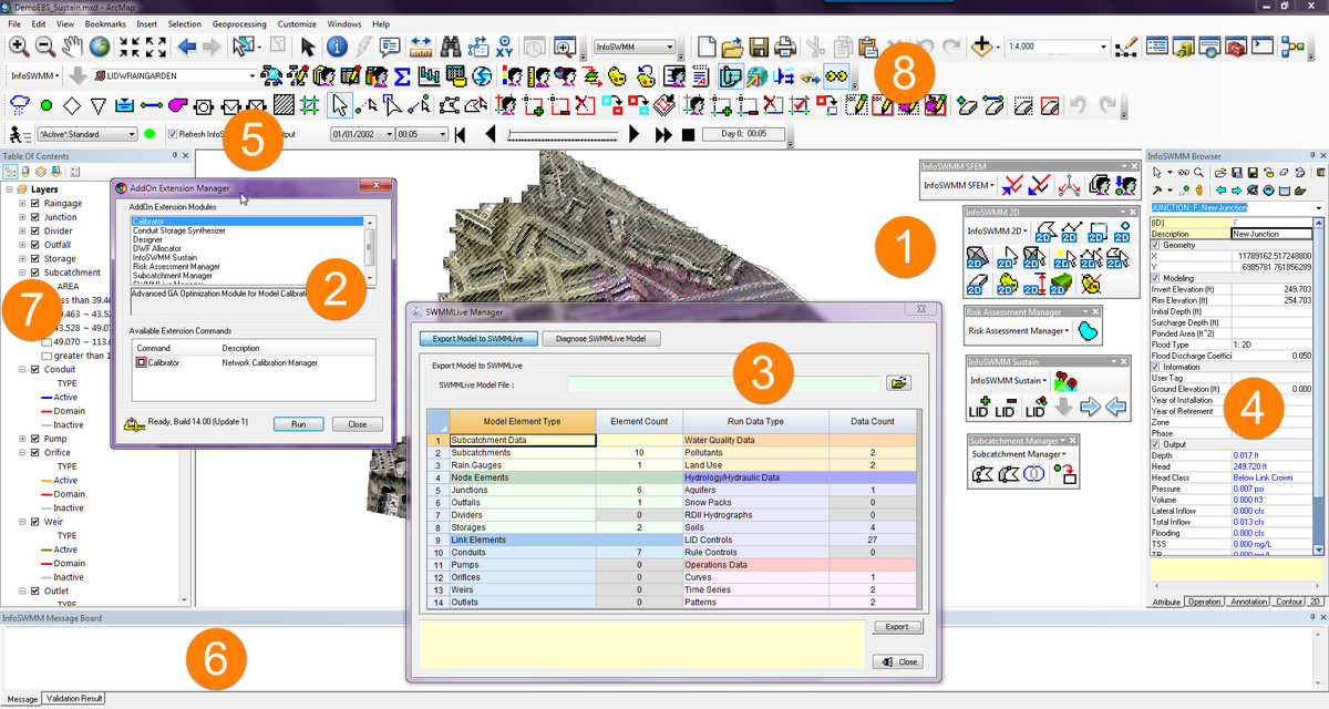
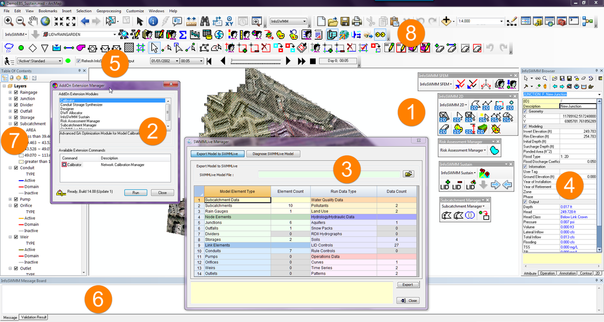
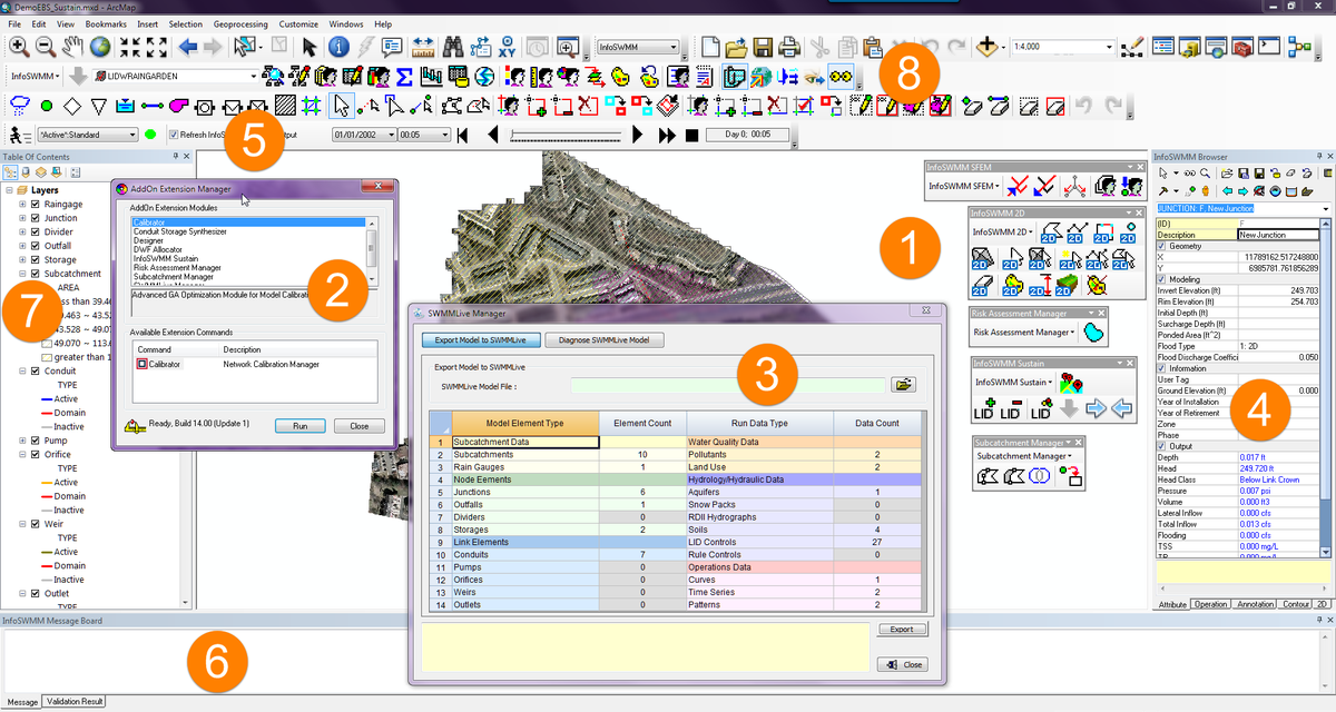
Components of #INFOSWMM from @Innovyze


Tweets - Components of #INFOSWMM from @Innovyze

  1. 8/ Components of from Managers of your Map and DB Data Bullet 8
  2. 7/ Components of from Map Table of Contents Map to DB Link for GIS or Bullet 7
  3. 6/ Components of from Message Box for User Information from Arc GIS or Bullet 6
  4. 5/ Components of from Tools for Adding New Map Features or Bullet 5
  5. 4/ Components of from Attribute Browser (AB) Map to DB Link or Bullet 4
  6. 3/ Components of from Spatial Analyst Components Bullet Three
  7. 2/ Components of from Genetic Algorithm Components Bullet Two
  8. 1/ Components of from Spatial Analyst Components Bullet One
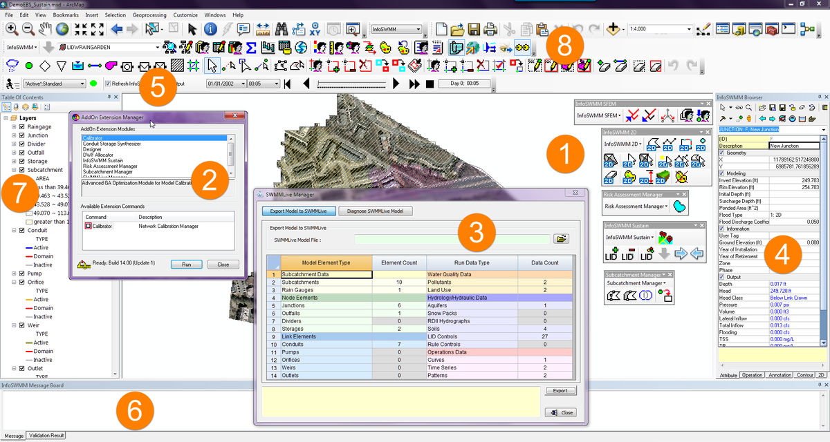
  9. 1/ Components of from Spatial Analyst Components Bullet One

Today is day 356 or 97.5 percent of the year 2024

English: Today is day 356 or 97.5 percent of the year 2024 Mandarin Chinese: 今天是2024年的第356天,即97.5% Hindi: आज 2024 का 356वां दिन या 97.5 प्रत...