Showing posts with label BMP. Show all posts

Friday, November 20, 2015

BMP, LID, SUDS, WSUD E INFRAESTRUTURA VERDE – PRÁTICAS QUE REVOLUCIONAM A DRENAGEM URBANA

This page has very good graphics on LID and SuDS
http://www.aquafluxus.com.br/bmp-lid-suds-wsud-e-infraestrutura-verde-praticas-que-revolucionam-a-drenagem-urbana/
 
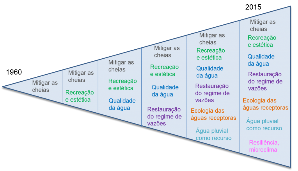
A urbanização provoca modificações no ciclo hidrológico, alterando suas parcelas e o balanço hídrico da bacia hidrográfica. A urbanização desordenada associada à falta de manejo e ao uso inadequado do solo provoca a redução da capacidade de armazenamento natural dos deflúvios, modificando os padrões de drenagem. A solução tradicionalmente adotada para a drenagem urbana visa o aumento da velocidade dos escoamentos com obras de canalização dos rios, o que acaba transferindo o problema para jusante e implica em continuadas intervenções localizadas após eventos de inundação. No entanto, uma abordagem mais atual, a chamada Drenagem Urbana Sustentável, busca soluções que proporcionam aretenção artificial das águas pluviais, a fim de compensar as perdas na retenção natural. A figura abaixo mostra a evolução da gestão da drenagem urbana ao longo dos anos, que no princípio tinha como objetivo apenas mitigar a ocorrência de cheias e que hoje objetiva também a melhoria da qualidade das águas drenadas, a restauração do regime de vazões, o aproveitamento das águas da chuva, entre outros.

triânguloevolução drenagem
A drenagem sustentável tem como focos principais:
  • respeitar o funcionamento natural da bacia hidrográfica;
  • minimizar os impactos da urbanização;
  • melhor controle sobre os riscos de inundações;
  • menor custo com readequações do sistema de drenagem (custos com “reinvestimentos”).
Os projetos de sistemas de drenagem sustentável buscam soluções para a drenagem evitando que os problemas sejam transferidos para áreas vizinhas, bem como a diminuição do impacto do empreendimento no sistema hídrico e garantia de sua sustentabilidade. Nas últimas décadas foram propostas diferentes abordagens nesta mesma temática, todas com um objetivo comum de resgatar as características naturais do ciclo hidrológico e proporcionando, ao mesmo tempo, ambientes mais agradáveis, como já apresentamos aqui no Blog em outros posts.
A seguir são apresentadas, resumidamente, as principais abordagens e as características de cada uma.
Melhores práticas de gestão – BMP (Best Management Practices)
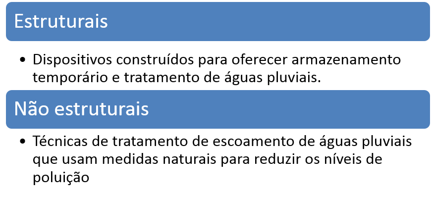
É um conjunto planejado de ações implementadas na bacia, com o objetivo de atenuar os impactos da urbanização, buscando reduzir a quantidade de água lançada no corpo receptor através da infiltração, e também melhorias na qualidade dessas águas. Exemplos típicos de BMPs incluem dispositivos de detenção ou retenção, instalações de infiltração e wetlands. Um exemplo de projeto com o uso destas técnicas foi apresentado no post EXEMPLO DE BMP PARA CONTROLE DE INUNDAÇÕES – LOS ANGELES, CA. As BMPs atuam tanto com medidas estruturais quanto com medidas não estruturais.
BMP
Desenvolvimento de Baixo Impacto – LID (Low Impact Development)
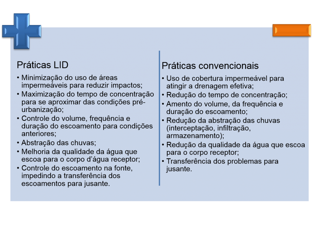
Considera o problema de forma integrada, tentando resgatar as características naturais do ciclo hidrológico, enquanto agrega valor à própria cidade. Projetos com uso de LIDs são elaborados de forma a se criar uma “paisagem multifuncional” capaz de incorporar características de projeto que buscam simular as funções de infiltração e armazenamento da bacia pré-urbanizada. Essa técnica foi bem explicada no post CRIANDO CIDADES SUSTENTÁVEIS. Abaixo são apresentadas as principais diferenças entre as práticas LID e as práticas convencionais.
LID
Técnicas compensatórias
Buscam favorecer a retenção e infiltração das águas precipitadas, visando o rearranjo temporal das vazões e a diminuição do volume escoado, reduzindo a probabilidade de inundações e aumentando a qualidade das águas pluviais. Tem como princípio inicial: manter as mesmas vazões das condições de pré-urbanização, buscando compensar os impactos da urbanização por meio da redução do volume de escoamento superficial, das vazões de pico e consequente redução da vulnerabilidade das áreas urbanas a inundações. O post O IMPACTO DAS TÉCNICAS COMPENSATÓRIAS apresentou um projeto acadêmico que testou o uso dessas técnicas.
Para saber mais sobre as técnicas compensatórias leia o post 5 MANEIRAS SIMPLES DE MELHORAR O CONTROLE DAS ENCHENTES URBANAS.
Sustainable urban drainage systems – SUDS
Desenvolvidos para melhorar o desenho urbano e a gestão de riscos ambientais, assim como promover a melhoria do ambiente construído, buscando reduzir os escoamentos superficiais através de estruturas de controle da água pluvial em pequenas unidades. Inclui medidas não estruturais como layouts alternativos de estradas e prédios para minimizar a impermeabilização dos solo e maximizar seu uso.
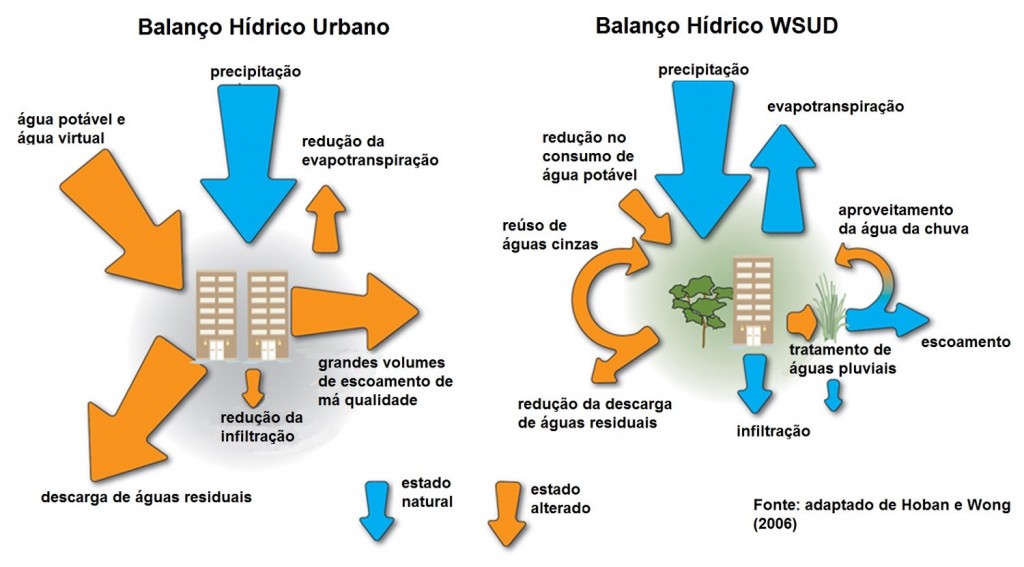
Water sensitive urban design (WSUD)
Como Osvaldo escreveu no post MANEJO DE ÁGUAS PLUVIAIS: QUEM ESTÁ INOVANDO NA ÁREA? , esse conceito “implica em inverter a lógica de adaptação dos sistemas hídricos às necessidades da cidade para uma abordagem de adaptação da cidade ao ciclo hidrológico, mitigando ao máximo os impactos da urbanização e aproveitando todo o potencial da água na paisagem e na vida urbana.”
Os princípios básicos são:
  • gestão integrada de água potável, águas residuais e águas pluviais;
  • integração da gestão das águas urbanas na escala individual do lote à escala regional;
  • integração da gestão sustentável das águas urbanas, arquitetura e paisagismo; e
  • integração das medidas estruturais e não-estruturais no manejo sustentável das águas urbanas.
wsud
Infraestrutura verde – GI (Green Infrastructure)
A infraestrutura verde coloca a conservação da biodiversidade num contexto político mais vasto, no qual os objetivos primários da conservação da natureza são alcançados em estreita harmonia com outros objetivos de uso do solo relacionados, por exemplo, com a agricultura, a silvicultura, o lazer e recreio e a adaptação às alterações climáticas. Intervenções urbanas que utilizam práticas da Infraestrutura Verde podem proporcionar maior infiltração da água e sua filtragem, bem como evapotranspiração e evaporação, reduzindo os efeitos de ilhas de calor e promovendo um melhor quadro climático na cidade. Além de atuar na gestão das águas pluviais também contribui na redução das enchentes e na melhoria da qualidade do ar. É o conceito mais amplo, dentre todos os apresentados.
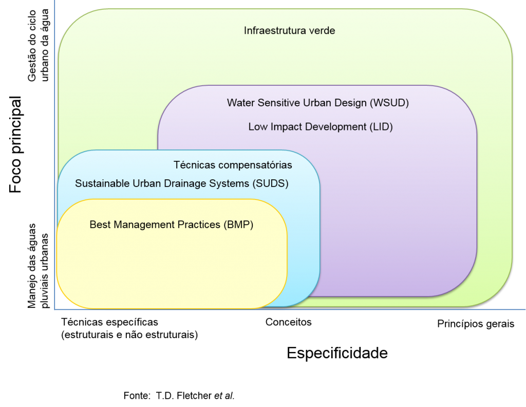
O quadro abaixo, apresentado no artigo SUDS, LID, BMPs, WSUD and more – The evolution and application of terminology surrounding urban drainage, publicado no Urban Water Journal, apresenta as diferentes concepções de acordo com suas especificidades e foco principal.
Tudo junto
Para saber mais sobre drenagem sustentável leia os posts:
DRENAGEM URBANA: CLÁSSICA X SUSTENTÁVEL
MAS QUAL É A VANTAGEM DA DRENAGEM SUSTENTÁVEL?)
Tuesday, August 4, 2015

Innovyze Offers Free Award-Winning GIS-Centric Water Modeling Software to Universities Worldwide Free Student Edition of Industry Leading InfoWater and InfoSWMM Aimed at Giving Students Hands-On Experience, Better Preparing Industry-Ready Workforce and Shaping the Future

Innovyze Offers Free Award-Winning GIS-Centric Water Modeling Software to Universities Worldwide

Free Student Edition of Industry Leading InfoWater and InfoSWMM Aimed at Giving Students Hands-On Experience, Better Preparing Industry-Ready Workforce and Shaping the Future

Broomfield, Colorado, USA, August 4, 2015

Fulfilling its promise of continually raising the bar in water resources engineering education and expanding the world of learning, Innovyze, a leading global innovator of business analytics software and technologies for smart wet infrastructure, today announced the availability of its industry-leading GIS-centric water and wastewater modeling software free to students and professors at higher education institutions worldwide. This special student edition of both InfoWater and InfoSWMM, limited to sixty links, is designed to provide universities worldwide with a simple, flexible way to use advanced, high performance water modeling software in their classrooms and labs. It will help students learn and develop important skills in the design, planning, operation and management of sustainable water distribution and wastewater/stormwater collection systems that will help them stand out in the job market.

Innovyze understands that civil engineering students need to be academically and professionally prepared for an engineering career. For students and professionals alike, there is no substitute for hands-on experience. Knowing this, more and more universities are helping students gain access to state-of-the-art and practical tools used in the classroom whenever and wherever they need them. By tailoring their undergraduate and graduate courses around Innovyze technology, engineering faculty members can be assured they are helping their students have direct access to the powerful tools and latest advances in smart water resources modeling technology they need to succeed— not only in the classroom, but ultimately as professional engineers.
“Innovyze InfoWater and InfoSWMM software has become a standard for many of the world’s largest water and wastewater utilities and top engineering firms,” said Scott Yost, Ph.D., P.E., Associate Professor of Civil Engineering at the University of Kentucky. “I can see this software being used by the best engineering schools. The Student Analysis and Design Workbooks are also excellent. Having training and education in this mission-critical technology is a major asset in validating our students’ expertise to prospective employers as well as preparing them for a rewarding career.”

Built atop ArcGIS (Esri, Redlands, CA), InfoWater’s innovative network modeling technology addresses every facet of utility infrastructure management and protection — delivering the highest rate of return in the industry. The software seamlessly integrates sophisticated predictive analytics, systems dynamics and optimization functionality directly within the powerful ArcGIS setting. From fire flow and dynamic water quality simulations, valve criticality and energy cost analysis to pressure zone management and advanced Genetic Algorithm and Particle Swarm optimization, the suite comes equipped with everything water utility owner-operators need to best plan, design, operate, secure and sustain their distribution systems.

InfoWater also serves as a base platform for advanced smart network modeling, operation, capital planning and asset management extensions. Among these critical applications are IWLive (real-time operations and security); InfoWater UDF (unidirectional flushing);CapPlan (risk-based capital planning); InfoMaster and InfoMaster Mobile (asset integrity management and condition assessment); InfoWater MSX (multi-species modeling); InfoWater BTX (event/particle backtracking); InfoSurge (surge/transient analysis); Sustainability (carbon footprint calculation); BalanceNet (real-time energy management and operations optimization); PressureWatch (real-time network hydraulic integrity monitoring); QualWatch (real-time network water quality integrity monitoring); SCADAWatch (real-time business intelligence and performance monitoring); DemandWatch (water demand forecasting); and DemandAnalyst (real-time water demand and diurnal pattern estimations).

As a complete ArcGIS-centric urban drainage modeling solution, the full-featured InfoSWMM analysis and design program delivers the highest rate of return in the industry. All operations of a typical sewer system — from analysis and design to management functions such as water quality assessment, pollution prediction, sediment transport and deposition, urban flooding, real-time control, and record keeping — are addressed in a single, fully integrated geoengineering environment. The program’s powerful hydraulic and water quality computational engine is based on an enhanced version of the latest SWMM 5.1.010, which is endorsed by the USEPA and certified by FEMA. These features and more deliver an enhanced modeling experience and greater realism of displayed results — advantages that translate to increased productivity, reduced costs, higher accuracy, better efficiency, and improved designs.

InfoSWMM also serves as a robust platform for advanced modeling, operational issues, short-term, long-range and capital planning, urban stormwater treatment and analysis, and analytics-driven asset management extensions. Some of these critical applications includeInfoSWMM 2D (two-dimensional surface flood modeling), CapPlan (risk-based capital planning and asset performance modeling),InfoSWMM Sustain (optimal selection and placement of LIDs/BMPs), InfoSWMM SFEM (dynamic sewer flow estimation model), InfoMaster(GIS-centric analytics-driven asset management), and RDII Analyst (rainfall-dependent inflow and infiltration planning and analysis).
A comprehensive Student Design and Analysis Workbook is also included for each program. In addition to background theory, the workbooks provide step-by-step approaches to water and wastewater network model construction, simulation and analysis, and are illustrated with a variety of carefully selected case studies to reinforce the hands-on nature of learning. By representing real-life network modeling situations, the workbooks are ideal for students to familiarize themselves with the day-to-day problem-solving work in engineering practice.

“Innovyze is committed to fostering technical achievement and technological advancement, both in teaching and research, throughout the engineering community,” said Paul F. Boulos, Ph.D., BCEEM, Hon.D.WRE, Dist.D.NE, Dist.M.ASCE, NAE, President, COO and Chief Technical Officer of Innovyze. “At a time when universities are faced with tighter budgets, our Student Software Edition offers these institutions the tools they need to teach their students using state-of-the-art technology and prepare them for rewarding professional careers. It allows students who are interested in the field of environmental and water resources engineering to train on the sophisticated technology used by leading water and wastewater utilities and progressive consulting engineering companies on a daily basis. This gives them an unbeatable competitive advantage and helps them to thrive. It also prepares them with the skills they need to meet industry demands, sustain our water infrastructures, advance our economies, and build a better world.”
Pricing and Availability
Special student edition of InfoWater and InfoSWMM along with their Student Design and Analysis Workbooks are available to download free of charge from the Innovyze website at http://www.innovyze.com/education/student/.
About InnovyzeInnovyze is a leading global provider of wet infrastructure business analytics software solutions designed to meet the technological needs of water/wastewater utilities, government agencies, and engineering organizations worldwide. Its clients include the majority of the largest UK, Australasian, East Asian and North American cities, foremost utilities on all five continents, and ENR top-rated design firms. With unparalleled expertise and offices in North America, Europe and Asia Pacific, the Innovyze connected portfolio of best-in-class product lines empowers thousands of engineers to competitively plan, manage, design, protect, operate and sustain highly efficient and reliable infrastructure systems, and provides an enduring platform for customer success. For more information, call Innovyze at +1 626-568-6868, or visit www.innovyze.com.
Innovyze Contact:Rajan RayDirector of Marketing and Client Service Manager
Rajan.Ray@innovyze.com
+1 626-568-6868

Wednesday, February 19, 2014

Thursday, August 8, 2013

LID and BMP Modeling in InfoSWMM and H20Map SWMM

Subject:   LID and BMP Modelling in InfoSWMM and H20Map SWMM

The attached PDF file describes some of the Low Impact Modeling and Best Management Practice modeling options in InfoSWMM and H2OMap SWMM (Figure 1)

Low Impact Development (LID)                                                           Page 3
Low Impact Development (LID)                                                           Page 4
LID Controls and Connection to the Subcatchments                          Page 5
Simulation Options for LID's                                                                 Page 6
Water Quality Features                                                                         Page 7
External Loading Buildup                                                                    Page 8
Simulation Options for Quality                                                            Page 9
Buildup/Washoff Options                                                                    Page 10
LID's are Unlimited Per Subcatchment                                            Page 11
Map Display of the Number of Units per Subcatchment                Page 12
LID Controls in DB Tables                                                                   Page 13
LID Layers                                                                                            Page 14
LID Storage Layer                                                                               Page 15
LID Process Components Page                                                            Page 16
LID Processes                                                                                     Page 17
LID Usage in DB Tables                                                                      Page 18
LID Usage at the Subcatchments                                                        Page 19
Rain Barrel LID                                                                                   Page 20
Swale LID                                                                                          Page 21
Components Per Subcatchment                                                          Page 22
LID Report Variables                                                                           Page 23
LID Report Text File                                                                            Page 24
LID Summary Report                                                                          Page 25
LID Report at a Time Step                                                                   Page 26
LID Graphs by Subcatchment                                                              Page 27
LID Import and Export to SWMM                                                         Page 28


Figure 1.  LID Options include on a Subcatchment include Rain Barrels, Bio-Retention Cells, Infiltration Trench, Porous Pavement and Vegetative Swales


Friday, November 9, 2012

What are the LID Control Flow Source Options in SWMM 5?

What are the LID Control Flow Source Options in SWMM 5?

The SWMM 5 options for Low Impact Development (LID) controls on a Subcatchment are very flexible, exciting, possibly recursive and a completely integrated method to treat both the pervious and impervious flow.  You can send the Subcatchment runoff to either an outlet node, impervious area of the Subcatchment, the pervious area of the Subcatchment or another Subcatchment.   You can have the LID control receive a portion or all of the impervious flow OR as in the EPA SWMM 5 LID example have the LID cover the whole Subcatchment and receive both impervious and pervious flow from one or multiple upstream Subcsatchments.  For example,  Subcatchment Swale4 in Figure 1 is 100 pervious and has upstream runoff from the pervious and impervious areas of Subcatchments S1, S3 and S4 in Figure 1.  The LID can also have either an outlet node or the pervious area of the Subcatchment on which it resides.


Thursday, August 16, 2012

Fifty Years of Watershed Modeling – Past, Present and Future

Fifty Years of Watershed Modeling –
Past, Present and Future
September 24-26, 2012
Boulder, Colorado
On behalf of Engineering Conferences International and the conference chairs, Anthony S. Donigian, Jr. (AQUA TERRA Consultants), andRichard Field (US Environmental Protection Agency/ORD [retired], Michael J. Baker Jr., Inc.), it is my pleasure to extend this invitation to you to participate in Fifty Years of Watershed Modeling – Past, Present and Future to be held September 24-26, 2012 at NCAR (National Center for Atmospheric Research – Center Green Campus) in Boulder, Colorado.
Continuous Simulation using SWMM 5 LID and Groundwater Features in a Linked 1D/2D Network using InfoSWMM 2D for a 50 Year Period

has been accepted for Poster Presentation at the forthcoming conference Fifty Years of Watershed Modeling: Past, Present and Future to be held September 24-26, 2012 at National Center for Atmospheric Research (NCAR – Center Green Campus) in Boulder, Colorado.

Monday, July 30, 2012

InfoSWMM v11.1 Changes to Date


InfoSWMM v11.1:

Support ArcGIS 10.1.
InfoSWMM or H2OMAP SWMM import: corrected the typos in error messages. (HsHxfSvr.dll, N/A, 6/22/2012)
Improvement: for better hours/minutes listing in Report Manager Report Table for Continuous Simulation with Odd Report Time Step Intervals.  For example, this fix improved the output time display for irregular (in

60 minute sense) output time steps.  Now it displays 00:50, 01:40, etc. more correctly than before (00:49, 01:39, etc). (HsOutPkg.dll, N/A, 6/21/2012)
Improvement or Bug Fix:
Added an IF statement to the RDII Unit Hydrograph Convolution for the  rare instances in which the user sets the time base of the UH to zero by setting either T or K to zero.  The Time Base is T*K in the

convolution integral and zero values are not allowed.  This bug was also forwarded to the EPA for a future SWMM 5.  The convolution uses the value of R and the Time Base to estimate the amount of Infiltration and

Inflow in the Sewer Network.  The short, medium and long term UH’s are estimated at each Wet Hydrology time step to make a smooth hydrograph out of the R, T and  K parameters of the Rainfall Dependent Infiltration

and Infiltration Method. (HsEngPkg64.dll and HsEngPkg.dll, N/A, 6/21/2012)

Improvement: More information for the user when one of nine SWMM 5 warning messages are listed in the HTML Output File. (HsEngPkg64.dll and HsEngPkg.dll, N/A, 6/21/2012)
                These are the nine SWMM 5 Warning Messages
                "WARNING 01: wet weather time step reduced to recording interval for Rain Gage"
                "WARNING 02: maximum depth increased for Node"
                "WARNING 03: negative offset ignored for Link"
                "WARNING 04: minimum elevation drop used for Conduit"
                "WARNING 05: minimum slope used for Conduit"
                "WARNING 06: dry weather time step increased to the wet weather time step"
                "WARNING 07: routing time step reduced to the wet weather time step"
                "WARNING 08: elevation drop exceeds length for Conduit"        
                "WARNING 09: time series interval greater than recording interval for Rain Gage"
                And Here is the Extra Information Now Saved to the HTML Output File in case the user wants to know what is used internally in the engine.  This is especially handy information when moving a SWMM 5 model to

                IWCS or ICM.
Application Framework: introduce the new “Inherited” Facility Set option.  Scenario can now inherit facility selection from its ancestor which possesses a non-inherited facility definition. (HsCadPkgPkg.dll,

HsUI2Pkg.dll, and HsDBBPkg.dll, N/A, 6/21/2012)
                                       New Option in DB Tables for Scenarios

Correction:
The export to the hydqua.inp file when you solve a H2OMAP SWMM model now includes the infiltration data even if the Subcatchment DB Infiltration column is blank after the import of a SWMM 5 file.  The blank row

defaults to the global Infiltration option in Base Simulation Options. (HsDataPkg.dll, N/A, 6/14/2012)
Correction:
Eliminated a duplicate graph of storage infiltration in the Low Impact Development. (HsOutPkg.dll, N/A, 6/14/2012)

Correction:
Implemented a future EPA fix for infiltration loss on a pervious surface if snowmelt is being simulated.   This fix will be part of SWMM 5.0.023. (HsEngPkg64.dll and HsEngPkg.dll, N/A, 6/13/2012)
The error was the double counting the accumulation of snow cover as infiltration in the mass balance table – here is the mass balance without the fix in SWMM 5.0.022

Fixed the problem of Edit Domain Attribute.  It was caused by a table relate issue in DB engine. (HsMapSrv10.dll, N/A, 5/29/2012)
Recompiled to fix a compatibility issue of the validation tool. (HnUtl.dll and HsUtlSrv.dll, N/A, 5/29/2012)

CapPlan
-------
Fix flowchart run issue. (HsCIPSrv.dll, N/A, 5/29/2012)

InfoSWMM v11 Update 10:

Changes & Improvements

Fix subcatchment vertex export issue for EPS-SWMM. (H2OSWMM.exe, N/A, 4/18/2012)
Scenario Comparison: Now, the “Hide Unchanged Column(s)” right-click command works correctly. (HsUI2Pkg.dll, N/A, 4/17/2012)
Netview Storage/Wet-Well Output: Fixed an invalid output data field problem. (HsOutPkg.dll, N/A, 4/12/2012)
Scenario Comparison: Fixed Duplicated ID Alias problem. (HsUtilPkg.dll and HsDBBPkg.dll, N/A, 4/11/2012)
Crashed Project Restoration: Now, active scenario ID could be reliably restored


RDII
-----
Check negative GA Hydrograph solution value during export back to InfoSWMM or H2OMAP SWMM. (HsRDIIPkg.dll, N/A, 5/3/2012)

InfoSWMM v11 Update 9:

Changes & Improvements

Simulation Run Report : Added a Scenario data source reference to the title notes section of the RPT file. (HsEngPkg.dll, HsEngPkt64.dll, and HsDataPkg.dll, N/A, 3/15/2012)
Simulation Run Output Data Access: Improved 64-bit access reliability for simulation run output data. (HsEngPkg.dll, HsEngPkg64.dll, and HsOutPkg.dll, N/A, 3/19/2012)
Small Time Base fix for RDII flow to match an upcoming SWMM 5 version (HsEngPkg.dll, HsEngPkt64.dll, and HsDataPkg.dll, N/A, 3/16/2012) :
Description: SWMM 5 makes the time interval used for convoluting the unit hydrographs within a group the smaller of the wet runoff step and the smallest time to peak for the

hydrographs in the group. This works OK when all the hydrographs have rising limb durations no longer than that of the falling limb (i.e., K >= 1.0). For example, the short term

UH has a K value of 0.3, with rising limb time of 42 minutes and falling limb time of  12.6 minutes. As a result, the time interval selection rule stated above was producing too

large a time step for a wet runoff step of 30 minutes causing the convolution to ignore a good portion of the UH.  The rule was modified to compare the wet step to the SMALLER of

the time to peak and time to recede.
Importance of this  for past and future InfoSWMM and H2OMAP SWMM models:

1.            Again, it is a significant and BETTER reason to use the current SWMM 5 engine over v13 of the SWMM 5 engine,
2.            It makes the convolution more robust for a small time base in the RTK method or the Time Base= T*K
3.            It may cause RDII flow differences in this engine if T*K is small over past engines

Add Vertical Roughness to preferences dialog. (HsMapSrv.dll, N/A, 4/4/2012)

2D
---
Upgrade

InfoSWMM v11 Update 8:

Changes & Improvements

Retain the compatible size for dialog boxes with fixed frame when user changes the screen resolution (DPI) in Windows 7. (HnUtilPkg.dll, N/A, 2/15/2012)
Support upcoming Innovyze application data folder and new product configuration file location. (HxLoader.dll, N/A, 2/15/2012)
Fix:  Improved the Change ID beep interval  for a change to the element ID using the Change ID Command. (HsUtilPkg.dll and HsCadPkg.dll , N/A, 2/4/2012)
Import of a SWMM 5 File with a Duplicate ID now tells you the name and class of object that is duplicated so it can be edited in SWMM 5.(HsDataPkg.dll, N/A, 1/31/2012):
New Feature (HEC_HMS_HYETOGRAPHS.inp, N/A, 2/2/2012): 
How to import the 44 possible SCS Storms from HEC-HMS.  The file HEC_HMS_HYETOGRAPHS.inp is imported into  InfoSWMM using the command Import EPASWMM 5 Data to import just the Raingage and Timeseries data from SWMM5.  The Timeseries data is a copy of the HEC-HMS data for each of the possible SCS Storms for SCS Type1, Type1A,  Type2 and Type3 for 1 minute, 2 minute, 3 minute, 4 minute, 5 minute, 6 minute, 10 minute, 15 minute, 20 minute, 30 minute and 1 hour intervals, respectively.   This is done so that the user of InfoSWMM has the option of using the exact HEC-HMS dimensionless precipitation for every interval and every SCS Storm Type.
New Feature (huff.inp, N/A, 2/2/2012):
How to import a dimensionless Huff distribution into InfoSWMM from http://www.alanasmith.com/theory-Derivation-Huff-Storm.htm using the SWMM 5 Import Command and a simple SWMM 5 file with Huff Distribution Rainfall.

CapPlan
--------
Fix Final Summary Report Field Offset. (HsCIPSrv.dll, N/A, 2/29/2012)
Fix database compatibility after version upgrade for Final Condition calculation (HsCIPSrv.dll and HsCIPSrv10.dll, N/A, 3/2/2012)

InfoSWMM v11 Update 7:

Changes & Improvements

Altered the last cumulative rainfall value to use exclusively the polynomial value. (HsUI4Pkg.dll , N/A, 1/18/2011)   
The ending value for example for a 10 inch hyetograph is now

SCS1         9.9 inches
SCS1A     10.008 inches
SCS2        10.0  inches
SCS3        10.0  inches

For the 4 types of SCS Hyetographs, instead of setting the ending rainfall value to 10 inches which caused a small spike in the SCS Type 1 hyetograph for the last point in the SCS hyetograph


CapPlan
--------
Fix FlowChart Analysis when project does not have CCTV data. (HsCIPSrv.dll, N/A, 1/20/2012)

InfoSWMM v11 Update 6:

Integration of Arc GIS 9.3 and Arc GIS 10.0 Installs

InfoSWMM v11 Update 5:

Changes & Improvements


SWMM 5 Export of Dry Weather Flow (HsDataPkg.dll , N/A, 10/25/2011) :
                1.            Many of our users use our DWF Allocator to assign dry weather flow to nodes based on meter data or loading areas
                2.            If they do this improperly then they may get many rows of DWF with zero flows in H2OMAP SWMM
                3.            This does not matter to H2OMAP SWMM as unlimited loads can be assigned to a node but
                4.            This is a problem in the export to SWMM 5 as SWMM 5 has a limitation of one DWF load per node
                5.            Zero DWF loads at a node are now NOT exported to SWMM 5 which makes this more compatible with the internal rules of SWMM 5
                6.            Only Non Zero DWF’s are now Exported
Fixed Dialog Display Issues for Annotation Dialog – moved label frames for overlapping frames.  Annotation is the 3rd Tab in the InfoSWMM Attribute Browser. (HsMapSrv10.dll, N/A, 10/24/2011)

Fix Validation Rule Buffer issue. (HsUI4Pkg.dll, N/A, 10/21/2011)

Fix:   A Change to the  Rule Control Status from Open/Close to On/Off for EPA SWMM 5 Control Section Compatibility. (HsUI4Pkg.dll, N/A, 10/20/2011)

                [CONTROLS]
                RULE LS-32_PMP-1
                IF PUMP LS-32_PMP-1 STATUS = ON
                AND PUMP LS-32_PMP-1 STATUS = ON
                THEN PUMP LS-32_PMP-1 SETTING = 0.100000
                PRIORITY 1.00000

                RULE LS-32_PMP-1A
                IF NODE LS-32 DEPTH > 6.250000
                AND PUMP LS-32_PMP-1 STATUS = ON
                THEN PUMP LS-32_PMP-1 SETTING = 0.750000
                PRIORITY 1.0000

Fix dialog boxes display issues for Win7. (HsMapSrv10.dll, HsCIPSrv10.dll, and HsCIPSrv10.dll, N/A, 10/21/2011)

CapPlan
--------
Improve Scoring Speed for Pipe Condition Scores. (HsCIPSrv.dll, N/A, 12/5/2011)

InfoSWMM v11 Update 4:

Changes & Improvements

DB Editor: Newly Added Information Field won’t appear until the table is re-opened.  It is now fixed. (HsUtilPkg.dll and HsDBBPkg.dll, N/A, 10/5/2011)
Attribute Browser:  Edit Junction Tables All, Domain and Selection were not loading – it is now fixed. (HsHxfSvr.dll and HsDBBPkg.dll, N/A, 10/2/2011)
Fixed a Windows 7 display issue of Preferences dialog.

Attribute Editor: Prevented the dialog switching to the first tab when users sort a data column.   This is now fixed. (HsMapSrv9.dll and HsMapSrv10.dll, N/A,10/2/2011)
                Edit Selection Attributes
                Edit Domain Attributes
                Group Editing on Selection
                Group Editing on Domain

Subcatchment
--------------
Subcatchment Manager:  Improved the Exception Handling for Creating Subcatchments. (HsSubcatchSrv10.dll , N/A, 10/11/2011)

InfoSWMM v11 Update 3:


New = A very important feature in InfoSWMM and H2OMAP SWMM is the ability to have Network Scenario’s.   Each Network Scenario is either a Base Scenario or a Child Scenario of the Base Scenario or other Child Scenario’s.    The Child Scenario’s may have different Data Set’s associated with them but previously in InfoSWMM and H2OMAP SWMM you could only use the DB Editor with the Data Sets in the Active Scenario.  
You can now use the DB Editor to edit ANY Data Set from any Scenario by using the new Data Set Selection Command at the bottom of the DB Open Table Dialog or by clicking on the ellipsis at the bottom of the dialog. (HsDBBPkg.dll, N/A, 8/26/2011)
An Internal Engine Feature in SWMM 5 and of course in H2oMAP SWMM and InfoSWMM is the automatic raising of the node rim elevation when any connecting pipe crown, weir or orifice is above the existing rim elevation.   Many users of our software use this feature to eliminate the need for entering node maximum depths.  The input HGL profile for would show the zero maximum depth of the node – this is now fixed and the program will plot the highest connecting link crown as the node rim elevation. (HsUI3Pkg.dll and HsOutPkg.dll, N/A, 8/26/2011)
HGL Visual Representation of Weirs, Orifices and Outlets in Input and Output HGL Plots
- Weir, Orifice and Outlets Inverts and Crest Elevation are now shown flat to correspond to the SWMM 5 internal Engine Convention
Link[j].offset2 = Link[j].offset1;. (HsUI3Pkg.dll and HsOutPkg.dll, N/A, 8/26/2011)
The infiltration or evaporation storage node or pond in InfoSWMM may be simulated using Green Ampt Infiltration and Pan Evaporation using options in the Attribute Browser. (HsEngPkg.dll and HsEngPkg64.dll, N/A, 8/31/2011)
                The fixes are:
                1.            The System Evaporation is now in units of inches/day or millimeters/day
                2.            Extra Decimal places were added to the Storage Summary Table


CapPlan
----------
Fix buffer unit conversion so that the proper judgment about the closeness of two pipe defects so that the program may consider merging them. (HsCIPSrv10.dll , N/A, 9/12/2011)
Fix cost lookup with Max. Depth and Min Depth. (HsCIPSrv10.dll , N/A, 9/19/2011)

2D
---
Trying to color code 2D results might crash the program after mesh data was manually deleted.  Now it has been fixed. (HsSDServices.dll , N/A, 9/14/2011)
DB Editor: Allow the user to edit data table of any desired DATA SET. (HsDBBPkg.dll , N/A, 8/22/2011)

InfoSWMM v11 Update 2:

Exchange\Import EPA SWMM 5 Command:
The Offsets Elevation Flag in a SWMM 5 import data set is now both imported and translated to the Store Absolute Condit Invert Flag in Tools Preferences/Operation in InfoSWMM.  This allows more SWMM 5 compatibility for the InfoSWMM flags using the Import EPA SWMM 5.0.001 to EPA SWMM 5.0.022 Command. (HsDataPkg.dll, N/A, 7/29/2011)
HGL Profile for Small q/Q values:
The output report manager HGL Profile no longer sets the color of the link fill  to white when the value of q/Q and the velocity are both small.  A value of d/D of 1 will still show a blue fill color in the HGL Plot. (HsOutPkg.dll, N/A, 7/29/2011)
Fix of a Hyetograph Name Typo and Reordering. (HsUI4Pkg.dll, N/A, 8/8/2011)
SCS Hydrology CN Printout Clarification: CN in the Output Text File and Output Report Manager. (HsEngPkg.dll and HsEngPkg64.dll, N/A, 8/4/2011)
Trace Network: Insufficient memory allocation for model with long IDs caused the program to crash in Arc GIS.  It is now fixed. (HsUI2Pkg.dll, N/A, 8/4/2011)
Just a reminder as well for Joe – all of Chun-Hou’s recent changes for SCS Hydrology are NOT in the most recent install.  8/11/2011 hsnetviewsrv10.dll
Project Init & Save: support the new ESRI File Geodatabase project. (HeUtilPkg.dll, N/A, 8/18/2011)
Add Risk Tile to report and summary. (HsCIPSrv.dll, N/A, 8/19/2011)


InfoSWMM v11 Update 1:

Output Relate: Fixed Output Relate generation problem for the Junction Summary report. (HsOutPkg.dll, N/A, 6/23/2011)
Increased Mix Graph Options for Outfall Data and System Data. (HsUI2Pkg.dll and HsEngPkg.dll, N/A, 6/6/2011)
Name change for Innovyze-SWMM LID Report File
Importing EPA SWMM file was using an incorrect file selection dialog.  Now it has been fixed.
An update to the DWF Pattern Calculation at Hour 24 when using Variable Time Step.  The pattern is now set at the pattern at hour 23 based on pattern hours from 0 to 23. (HsEngPkg.dll, N/A,

5/27/2011)
Previously, the Variable Time Step would have an undefined pattern value at hour 24 when the variable time step option was used but fixed time step was properly set to the pattern at hour 23.
Missing file (HnFileMonitor.dll, N/A, 6/7/2011)
Enhanced Low Impact Development (LID) Water Quality Graphics and Report. (HsStatPkg.dll,HsOutPkg.dll HsEngPkg.dll, HsEngPkg64.dll, N/A, 6/7/2011)

Fix the Low Impact Development LID (HsUI4Pkg.dll, N/A, 7/21/2011)  M
Underdrain Height Offset Dialog Unit.
The Underdrain Process Layer consists of:
                1.            Drain Coefficient (inches/hour or millimeters/hour)
                2.            The Void Ratio as a Fraction (0 to 1),
                3.            Drain Exponent
                4.            Drain Offset Height (inches or millimeters)

Changed the name of the Checkbox for Saving Output in the Low Impact Development (LID) Usage Editor for Subcatchments.  The Checkbox if checked saves the detailed LID Control Pathways for each

Control in a Subcatchment (HsUI4Pkg.dll, N/A, 7/20/2011)  M

Output Report Manager: A Change to the Output Report Manager to better handle 1 second time steps in the Report Table Section.  This was added to better see the output for Pumps and Force Mains when the Pumps turn on for only a few seconds.  It also allows the user to see the output data and graph a subset of a  long simulation run.  For example, if the user saves at a one second time step for a week this will allow him or her to see all 604800 data points and graph or perform statistics on 5 second  intervals if needed.  It was needed for those simulations in which the Maximum and Report Time Steps are the Same and the time step is small.  If you do save a million or more data points it would behoove you to use the Domain only as the Output Scope in the Run Manager to cut down on graphing time and the Out Folder Size. (HsOutPkg.dll, HsEngPkg.dll, N/A, 7/15/2011)  M

Browser Simulation Report: Added the Outfall Loading Summary to the Browser Simulation Report to be compatible with the SWMM 5.0.022 Status Report; this information has been and is also available as a Tabular Report in the Output Report Manager
The change is for both the 32 and 64 bit Engines as well as the Output Report Manager. (HsEngPkg64.dll, N/A, 7/15/2011)  M

Put in the LID Help ID and Help Topics connected to the Help ID. (HsUI4Pkg.dll, N/A, 7/26/2011) 

Increased Mix Graph Options for Outfall Data and System Data. (HsUI2Pkg.dll and HsEngPkg.dll, N/A, 6/6/2011)
Name change for Innovyze-SWMM LID Report File
Change MWH Soft to Innovyze in Preferences/Operation Settings tab. (HsMapSrv.dll and HsMapSrv10.dll, N/A, 6/2/2011)
Importing EPA SWMM file was using an incorrect file selection dialog.  Now it has been fixed.
An update to the DWF Pattern Calculation at Hour 24 when using Variable Time Step.  The pattern is now set at the pattern at hour 23 based on pattern hours from 0 to 23. (HsEngPkg.dll, N/A,

5/27/2011)
Previously, the Variable Time Step would have an undefined pattern value at hour 24 when the variable time step option was used but fixed time step was properly set to the pattern at hour 23.
Missing file (HnFileMonitor.dll, N/A, 6/7/2011)

Hide cross section browser after loading. (H2OSWMM.exe, N/A, 5/16/2011) H
Recompile due to compatibility for the Validation and Audit Tools. (HsUtlSrv.dll, N/A, 5/16/2011) I
Updated EPA SWMM 5 Engine: Updated the InfoSWMM engine to be compatible with the new SWMM 5.0.022 Version. (HsDataPkg.dll, N/A, 5/19/2011)
Fixed 2D license pop up. (HsUI4Pkg.dll, N/A, 5/24/2011) I
Fixed CapPlan license pop up. (CapPlanSvr, N/A, 5/23/2011) I


InfoSWMM Executive Products:
RDII
-----
Fix RDII Analyst GWI calculation  Support Case ID:  18853. (HsRDIIPkg.dll, N/A, 7/26/2011) M

InfoSWMM v11:

Changes & Improvements
----------------------
Add CCTV Grade Source Field, allow CCTV as a rehab for Asset Grading, and change Advanced Scheduling to allow CCTV Rehab. (HsCIPSrv.dll, N/A, 10/8/2010)
Export [POLLUTANTS] Data to EPA-Swmm: fixed missing Pollutant ID data problem when the Description field is missing. (HsDataPkg.dll, N/A, 10/22/2010)
Google Map Link: updated to support new Google map URL syntax. (HaMapSrv.dll, N/A, 10/26/2010)
Output Report / Graph: enlarged time drop-down combo boxes to accommodate longer simulation periods. (HnUI2Pkg.dll, N/A, 11/2/2010)
Output Manager Display: Fixed invalid Result error problem when the report time step is small to include the extended Second portion. (HsOutPkg.dll and HsUI3Pkg.dll, N/A, 11/2/2010)
Model Data Generation to Run Simulation: Fixed an invalid flow unit problem when the DB table flow unit field is undefined. (HsDataPkg.dll, N/A, 10/27/2010)
Fix to the Santa Barbara Urban Hydrograph Method to match the UG equation 42’s usage of impervious area. (HsEngPkg.dll, N/A, 10/27/2010)
Add Media Player Detection message and fix radio button in Planning due to Windows 7. (HsCIPSrv.dll , N/A, 11/15/2010)
Fix BiDirectional Risk Calculation. (HsCIPSrv.dll , N/A, 11/24/2010)
Allow users to zoom into the map in field report. (Template\CIP\report folder , N/A, 11/20/2010)
Add Google Map to Field Report. (HsCIPSrv.dll , N/A, 11/20/2010)
Fixed a crash problem of Dual Drainage. (HsMapSrv.dll , N/A, 12/01/2010)
Compatibility Fix to Engineering Review Tools and Network Audit Tools for Arc GIS 9 to prevent a Type Mismatch Error. (HsUtlSrv.dll , N/A, 12/15/2010)
This file should go into C:\Program Files\Common Files\MWH Soft Shared. (HsUtlSrv.dll , N/A, 12/15/2010)
Improved the connection algorithm for the Locate/Fix Conduit Split Candidates Tool as in InfoWater. (HsMapSrv.dll , N/A, 12/15/2010)
Create Storage Curve: an error message will be issued if Spatial Analysis is not available to avoid program crash. (HsMapSrv.dll , N/A, 12/9/2010
                Please select a node  ...
                Please specify a storage area...
                ERROR 010096: There is no Spatial Analyst license currently available or enabled.
                No crash of program – just a message in the Message Area
New Requirement: When there is a set of outlets at each end of a pipe, the user has to manually create the Major Conduit. (HsMapSrv.dll , N/A, 12/7/2010)
New Message: Could not determine the shape of Major Conduit for conduit '8040A'.  Please manually create it.

RAM
---
Fix Based on Maximum Head in Create Flood Damage Extent Tool. (HsConseqSrv.dll, N/A, 3/5/2010)

AI Rivers of Wisdom about ICM SWMM

Here's the text "Rivers of Wisdom" formatted with one sentence per line: [Verse 1] 🌊 Beneath the ancient oak, where shadows p...