Showing posts with label InfoWater. Show all posts

Tuesday, August 30, 2016

InfoWater and InfoSewer ArcGIS-Centric Modeling Solutions to Help Hanford in Making Critical Decisions on Growth Planning and for Updating its General Plan

Innovyze Press Release
 Insider BlogLinkedInTwitterYouTubeYouTube
City of Hanford, California, Chooses Innovyze Advanced Smart Water Modeling Technology
InfoWater and InfoSewer ArcGIS-Centric Modeling Solutions to Help Hanford in Making Critical Decisions on Growth Planning and for Updating its General Plan
Broomfield, Colorado, USA, August 30, 2016 — Innovyze, a leading global innovator of business analytics software and technologies for smart wet infrastructure, today announced that the City of Hanford, California, has chosen Innovyze’s InfoWater and InfoSewer software as the foundation for supporting the update of the General Plan and for making critical decisions on growth planning.  The software will also be used for updating the City’s drinking water, sanitary sewer and storm drainage systems master plans, as well as for supporting the preparation of the Urban Water Management Plan to meet California Water Code requirements SB 610 and AB 910.
Established as the county seat for Kings County, California, Hanford has a population of about 55,000, with an average growth rate of 2% to 3% per year. Growth is anticipated to increase the population to 70,177 in 2020. The City’s drinking water system is comprised of 203 miles of main lines, 15 water supply wells, and 3.5 million gallons of storage tanks. Its sanitary sewer system consists of approximately 212 miles of main lines and 22 pump stations, and its storm drainage system comprises approximately 56 miles of main lines, 30 pump stations, and 181 acres of drainage basins.
“We selected InfoWater and InfoSewer because they have the power, functionality, and full-range capabilities we need to effectively integrate all our water and sewer network modeling activities directly with our GIS to increase productivity and create seamless workflows,” said Hanford Deputy Public Works Director and City Engineer John Doyel, P.E. “We were also impressed by the software’s ease of use, flexibility and value, as well as the excellent customer support and track record of Innovyze. They are helping our consultant update our Urban Water Management Plan and develop optimized solutions at maximum savings, so we can continue to deliver greater value to our customers.”
Built atop ArcGIS (Esri, Redlands, CA) with native geodatabase support, InfoWater and InfoSewer offer a single comprehensive, GIS-centric solution for analyzing and managing water distribution and sewer collections systems. The result is performance modeling that sets new levels of scalability, reliability, functionality and flexibility within the powerful ArcGIS environment. Using these advanced predictive tools, utilities can easily simulate and evaluate various conditions, pinpoint system deficiencies, and determine the most cost-effective improvements to achieve optimum performance and regulatory compliance and meet vital climate change and sustainability challenges.
“Innovyze offers by far the most comprehensive selection of ArcGIS-centric hydraulic modeling and management solutions in the water and wastewater industries,” said Paul F. Boulos, Ph.D., BCEEM, Hon.D.WRE, Dist.D.NE, Dist.M.ASCE, NAE, President, COO and Chief Innovation Officer of Innovyze. “These critical tools are designed to help our customers do their jobs better, faster and at lower cost. We’re proud to know that our InfoWater andInfoSewer solutions will be helping the City of Hanford build a foundation for success in the decades to come.”
About Innovyze
Innovyze is a leading global provider of wet infrastructure business analytics software solutions designed to meet the technological needs of water/wastewater utilities, government agencies, and engineering organizations worldwide. Its clients include the majority of the largest UK, Australasian, East Asian and North American cities, foremost utilities on all five continents, and ENR top-rated design firms. With unparalleled expertise and offices in North America, Europe and Asia Pacific, the Innovyze connected portfolio of best-in-class product lines empowers thousands of engineers to competitively plan, manage, design, protect, operate and sustain highly efficient and resilient infrastructure systems, and provides an enduring platform for customer success. For more information, call Innovyze at +1 626-568-6868, or visit www.innovyze.com.
Innovyze Contact:
Rajan Ray
Director of Marketing and Client Service Manager
Rajan.Ray@innovyze.com
+1 626-568-6868

Tuesday, January 5, 2016

Innovyze Ships InfoWater 2D — Next Generation of Two-Dimensional Modeling of Water Spill from Catastrophic Main Breaks

Innovyze Ships InfoWater 2D — Next Generation of Two-Dimensional Modeling of Water Spill from Catastrophic Main Breaks

First of Its Kind Release Equips Engineers with Unmatched Power to Predict Extent, Duration, Volume and Impact of Water Spill for Rapid, Effective Response Management

Broomfield, Colorado, USA, January 5, 2016

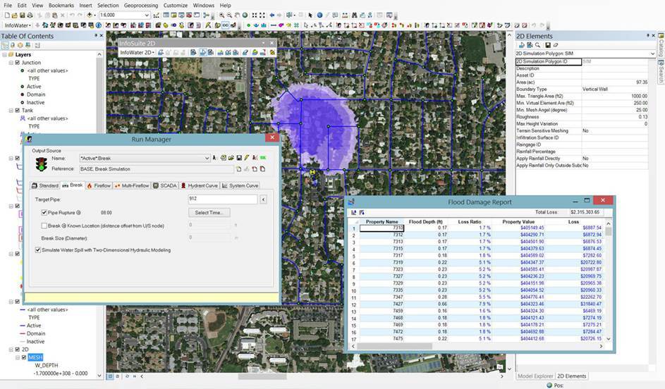
Innovyze, a leading global innovator of business analytics software and technologies for smart wet infrastructure, today announced the worldwide availability of InfoWater 2D, a breakthrough geospatial water distribution network management solution for accurate two-dimensional (2D) above-ground modeling of water spill from main breaks and large leaks, directly within the powerful ArcGIS (Esri, Redlands, CA) environment.

Globally, water demand is rising, aging water infrastructures are rapidly deteriorating, and the impact of water main breaks and leakage is relentless. In the U.S. alone, drinking water systems maintain more than two million miles of distribution mains with about 237,600 water main breaks occurring every year. An estimated seven billion gallons of clean drinking water are wasted every day — a staggering 2.6 trillion gallons annually. Catastrophic water main breaks can result in anywhere from millions to billions of dollars in damages including disastrous litigations.

InfoWater 2D demonstrates Innovyze’s ongoing commitment to delivering pioneering technology that raises the bar for water distribution network modeling and simulation, helping to shape the future of this critical sector. It gives water utilities the flexibility to continue to use the industry-leading and award-winning InfoWater ArcGIS-centric water distribution network modeling solution with added new power to predict the extent, duration, volume and impact of water spill from main breaks and large leaks for rapid, effective response management.

Built atop ArcGIS, InfoWater 2D solves the full range of 2D free-surface shallow water equations using a highly advanced and efficient finite volume method. It gives engineers the unprecedented power to predict and assess potential water spill extent, depth and velocity throughout the flooded area, with results viewable as graphs, tables or animated thematic flood maps. Users can also add parcel maps with property values (cadastral mapping) as well as curves of depth versus property damage to assess the impact of flooding resulting from catastrophic water main breaks. This information is important for insurance-related property valuation, utility liability, and other financial impacts. It is also critical in enabling water utilities and municipalities to proactively identify water mains with the potential for the worst damage and prepare effective emergency response plans.

InfoWater 2D greatly extends the core features of InfoWater, providing the most powerful and comprehensive ArcGIS-centric tool kit ever for estimating and managing the risks of water main breaks and large leaks,” said Paul F. Boulos, Ph.D., BCEEM, Hon.D.WRE, Dist.D.NE, Dist.MASCE, NAE, President, COO and Chief Technical Officer of Innovyze. “This milestone solution marks a new direction in advanced water distribution systems simulation and analysis. It is the only GIS-centric analysis, design and management software users need to work faster and smarter in a competitive environment — not only to power system performance, but to safeguard critical wet infrastructures and maximize their resiliency and effectiveness in protecting public health. This is the ultimate tool for accurately assessing the impacts of water main breaks and large leaks, then formulating and evaluating sound, cost-effective response strategies. Innovyze is very proud to offer this revolutionary emergency response product to our clients.”

Pricing and Availability
InfoWater 2D for InfoWater is available by subscription worldwide. Special upgrade prices are available for all existing InfoWater users. For the latest information on the Innovyze Subscription Program, including availability and purchase requirements, visit www.innovyze.com or contact your local Innovyze representative.
About InnovyzeInnovyze is a leading global provider of wet infrastructure business analytics software solutions designed to meet the technological needs of water/wastewater utilities, government agencies, and engineering organizations worldwide. Its clients include the majority of the largest UK, Australasian, East Asian and North American cities, foremost utilities on all five continents, and ENR top-rated design firms. With unparalleled expertise and offices in North America, Europe and Asia Pacific, the Innovyze connected portfolio of best-in-class product lines empowers thousands of engineers to competitively plan, manage, design, protect, operate and sustain highly efficient and reliable infrastructure systems, and provides an enduring platform for customer success. For more information, call Innovyze at +1 626-568-6868, or visit www.innovyze.com.
Innovyze Contact:Rajan RayDirector of Marketing and Client Service Manager
Rajan.Ray@innovyze.com
+1 626-568-6868

Tuesday, October 13, 2015

Innovyze Releases InfoWater Generation V12 With Advanced Pipe Break Break and Leakage Modeling

Innovyze Releases InfoWater Generation V12 With Advanced Pipe Break Break and Leakage Modeling

New Release Provides Mission-Critical Functionality For Proactive Management of Water Distribution Systems

Broomfield, Colorado, USA, October 13, 2015

In its ongoing quest to equip the global water industry with the world’s most powerful and comprehensive GIS-centric infrastructure modeling and management solutions, Innovyze, a leading global innovator of business analytics software and technologies for smart wet infrastructure, today announced the worldwide availability of the V12 Generation of InfoWater for ArcGIS (Esri, Redlands, CA). The release forcefully exemplifies  Innovyze’s strong commitment to meeting the requirements of its user base and the increasing demands of the global water industry.

Globally, water demand is rising, aging water infrastructures are rapidly deteriorating, and the impact of water main breaks and leakage is relentless. In the U.S. alone, drinking water systems maintain more than two million miles of distribution mains with about 237,600 water main breaks occurring every year. An estimated seven billion gallons of clean drinking water are wasted every day — a staggering 2.6 trillion gallons annually.

With this new version, Innovyze has further refined the superb water supply and distribution modeling and analysis features that have helped make InfoWater a leading choice among the world’s top water utilities and engineering firms. The award-winning software has long been renowned for its extreme performance and comprehensive toolsets and extensions. Now by enabling users to explicitly model water main breaks (and leaks), they can develop effective leakage reduction and control and demand and maintenance management strategies to maximize the quantity of revenue-producing water, ensure hydraulic and water integrity, improve the quality of service, and conserve this precious resource. Breaks can be specified for any pipe in the network along with their location, size, and time of occurrence. Small breaks can also be automatically distributed at the two end nodes of a pipe. InfoWater will then compute and report the total water volume lost to breaks and leaks for any user-specified period. It will also report their impact on the hydraulic (e.g., flows, pressures, velocities, and fire-fighting capacity) and water quality (e.g., chlorine concentrations) integrity of the water distribution system.

Built atop ArcGIS, InfoWater seamlessly integrates sophisticated predictive analytics, systems dynamics and optimization functionality directly within the powerful ArcGIS setting. From fire flow and dynamic water quality simulations, valve criticality and energy cost analysis to pressure zone management and advanced Genetic Algorithm and Particle Swarm optimization, the suite comes equipped with everything water utility owner-operators need to best plan, design, operate, secure and sustain their distribution systems.

The software also serves as a base platform for advanced smart network modeling, operation, capital planning and asset management extensions. Among these critical applications are IWLive (real-time operations and security); InfoWater UDF (unidirectional flushing);CapPlan (risk-based capital planning); InfoMaster and InfoMaster Mobile (asset integrity management and condition assessment);InfoWater MSX (multi-species, temperature, and particle transport/deposition modeling); InfoWater BTX (event/particle backtracking);InfoSurge (surge/transient analysis); Sustainability (carbon footprint calculation); BalanceNet (real-time energy management and operations optimization); PressureWatch (real-time network hydraulic integrity monitoring); QualWatch (real-time network water quality integrity monitoring); SCADAWatch (real-time business intelligence and performance monitoring); DemandWatch (water demand forecasting); and DemandAnalyst (real-time water demand and diurnal pattern estimations).

These advancements propel the InfoWater family of solutions into the next generation, furthering Innovyze’s time-honored practice of continually adding critical value to its software and bringing unsurpassed modeling and design capabilities into the mainstream. The suite has the robustness and feature set needed to handle the most demanding analyses. Yet it’s intuitive enough for new users to master without a drawn-out learning curve, making it the ultimate GIS-centric decision support tool for water supply and distribution systems. Like all Innovyze products, InfoWater V12 is backed by unparalleled high-touch technical support. For an even faster return on investment, organizations may opt to call on Innovyze Implementation Services to accelerate deployment, integration and implementation of best modeling practices.

“At Innovyze, we give our customers the fast, accurate and reliable simulation they need to predict real-world water infrastructure performance,” said Paul F. Boulos, Ph.D., BCEEM, Hon.D.WRE, Dist.D.NE, Dist.M.ASCE, NAE, the company’s President, COO and Chief Technical Officer. “Our new release makes it easy for engineers to quickly analyze, design and operate increasingly large and complex water distribution networks and derive solutions that help them achieve their most critical business goals. Specifically, it will help them minimize economic losses, ensure safety and control environmental problems. Our superior smart water network modeling and management solutions suite provides water operators and engineers the ultimate decision support tool for optimal results.”

Tuesday, March 31, 2015

Innovyze Announces Worldwide Support for EPANET and SWMM

Innovyze Announces Worldwide Support for EPANET and SWMM

Groundbreaking Initiative Facilitates Technology Transfer of Sustainable Water Infrastructure Models Between Global Communities

Broomfield, Colorado, USA, March 31, 2015

Innovyze, a leading global innovator of business analytics software and technologies for smart wet infrastructure, today announced worldwide support for USEPA’s flagship EPANET and SWMM public domain software. By offering its technical expertise to the EPANETand SWMM communities, Innovyze is ensuring ongoing maintenance of these free software models of sustainable stormwater, wastewater, and water supply systems.

Sustainable water infrastructure models are used throughout the world for the planning, analysis, design, and research of stormwater, wastewater, and drinking water distribution management. SWMM can model the generation and transport of runoff and sanitary flows as well as estimate the production of pollutant loads associated with this runoff in storm, sanitary or combined sewers. With the recent inclusion of hydrologic performance of specific types of green infrastructure low impact development (LID) controls the model can be used to consider both grey infrastructure approaches (e.g., pipes, tunnels, high rate treatment), and potentially more cost-effective green infrastructure approaches (e.g., rain gardens, permeable pavement, rain barrels) for managing stormwater. EPANET can help water utilities maintain and improve the quality of water delivered to consumers through their drinking water distribution systems. It can also be used to plan and improve a system’s hydraulic performance. The model can assist with pipe, pump, and valve placement; sizing; energy minimization; fire flow analysis; vulnerability studies; and operator training. Together, these models give municipalities the tools to help them develop cost effective green and grey water infrastructure options that reduce the release of untreated wastewater and improve the availability of safe drinking water.

“Innovyze is a pioneer in cutting edge sustainable water infrastructure modeling research and development,” said Paul F. Boulos, Ph.D., BCEEM, NAE, Hon.D.WRE, Dist.D.NE, F.ASCE, President, COO and Chief Technical Officer of Innovyze. “The company’s industry-leading GIS-centric InfoWater and InfoSWMM product suites greatly expand on the simulation and analysis capabilities ofEPANET and SWMM5 models. Ongoing maintenance of EPANET and SWMM is important both to us and to the global water and wastewater communities. It ensures the usefulness and longevity of these products for their users. We are pleased to launch this initiative to help further sustain the world’s wet infrastructures and provide solutions to such challenging problems as climate change, water security, and environmental compliance.

“We hope to continue to inspire water modelers worldwide and provide them the power tools to do the things that inspire them so that together we can build and sustain resilient water infrastructures that help drive the economy and create a better world for everyone.”

For more information about these products, visit Innovyze at www.innovyze.com and select “EPANET” or “SWMM.” Training classes onEPANET and SWMM will be available through the Innovyze University, http://www.innovyze.com/education/.

Pricing and Availability
Both EPANET and SWMM can be downloaded free directly from the Innovyze web site at www.innovyze.com. Access to the Innovyze User Forums is also available to seek answers and exchange information with the global water and wastewater modeling communities (http://forums.innovyze.com/).

About InnovyzeInnovyze is a leading global provider of wet infrastructure business analytics software solutions designed to meet the technological needs of water/wastewater utilities, government agencies, and engineering organizations worldwide. Its clients include the majority of the largest UK, Australasian, East Asian and North American cities, foremost utilities on all five continents, and ENR top-rated design firms. With unparalleled expertise and offices in North America, Europe and Asia Pacific, the Innovyze connected portfolio of best-in-class product lines empowers thousands of engineers to competitively plan, manage, design, protect, operate and sustain highly efficient and reliable infrastructure systems, and provides an enduring platform for customer success. For more information, call Innovyze at +1 626-568-6868, or visit www.innovyze.com.
Innovyze Contact:Rajan RayDirector of Marketing and Client Service Manager
Rajan.Ray@innovyze.com
+1 626-568-6868

Sunday, January 12, 2014

How to Create a Geodatabase in InfoWater, InfoSWMM or InfoSewer and InfoSWMM Data Sharing Ideas

How to Create a Geodatabase in InfoWater,  InfoSWMM or InfoSewer (Figure 1) and Ideas for Data Sharing for InfoSWMM or InfoSewer (Figure 2)

How to Create a Geodatabase in InfoWater,  InfoSWMM or InfoSewer
Data Sharing Ideas for InfoSWMM and InfoSewer

Tuesday, December 11, 2012

Batch Simulation in InfoSewer, InfoSWMM or InfoWater

Steps to set up a new icon for Batch Simulation in InfoSewer, InfoSWMM or InfoWater
1. Customize Arc GIS
2. Add an Icon
3. Run the command using the Icon


AI Rivers of Wisdom about ICM SWMM

Here's the text "Rivers of Wisdom" formatted with one sentence per line: [Verse 1] 🌊 Beneath the ancient oak, where shadows p...